
Christopher Tolkien, cartographer
Probably at this point everyone who knows anything about Christopher Tolkien, J.R.R. Tolkien’s youngest son, knows that he died this last weekend at the “ripe but disappointed age” of 95. (See LotR §1.03.015.)
I’ve been very happy to see that many of the obituaries and social-media posts have mentioned Christopher’s role as a cartographer — or indeed as the cartographer of Middle-earth. Today’s Tor article by Jonathan Crowe, “Celebrating Christopher Tolkien’s Cartographic Legacy,” though, is the only article I’ve seen that’s focussed entirely on the importance of Christopher’s map-making — not only to his father’s tales of Middle-earth and Beleriand, but also to the modern fantasy genre as a whole.
I celebrate this well-deserved attention. A few years ago, in fact, in a private letter to Christopher, I called him “the ‘father’ of Middle-earth cartography and scholarship.” In response, Christopher was very careful and very humble:
What Christopher said
I am no cartographer myself, unless one means simply that I have drawn a lot of maps of a most unusual kind! My object has always been no more than to discern, interpret, and represent on paper, largely following his own style, and as accurately as I could, my father’s intentions, notably of the endless movement of his conceptions that often make his own maps extremely difficult to interpret.
The humility of his response is, from what I’ve heard from those who knew him, entirely typical. Christopher’s work — cartographic and editorial — is indeed important and in many ways completely unprecedented.
But I think it’s important that we also consider his statement’s accuracy, particularly as we’re tempted to credit Christopher with setting “the norm for subsequent epic fantasy novels,” as Crowe writes.
Again, Christopher wrote that he’d tried to “discern, interpret, and represent” his father’s intentions “largely following his own style.” Really, this makes historical and practical sense.
What Christopher’s father said
Beginning with the autumn of 1953, when he was readying The Fellowship of the Ring for publication, Tolkien (the father) was up against the publisher’s deadline. Crowe quotes a letter (#141) to his publisher,
The Maps. I am stumped. Indeed in a panic. They are essential; and urgent; but I just cannot get them done. I have spent an enormous amount of time on them without profitable result. Lack of skill combined with being harried. Also the shape and proportions of ‘The Shire’ as described in the tale cannot (by me) be made to fit into [the] shape of a page; nor at that size be contrived to be informative.…
Crowe’s quotation stops here, but Tolkien continues:
I feel that the maps ought to be done properly.… Even at a little cost there should be picturesque maps, providing more than a mere index to what is said in the text. I could do maps suitable to the text. It is the attempt to cut them down and omitting all their colour (verbal and otherwise) to reduce them to black and white bareness, on a scale so small that hardly any names can appear, that has stumped me.
Crowe describes Tolkien’s own maps as “rough sketches, pencilled and inked and corrected over and over.” Absolutely, Tolkien painstakingly drew and edited and changed his mind and corrected his maps repeatedly, just as he did his manuscripts — and today most of them are quite difficult to interpret because of this. “Rough sketches” is pretty harsh, though. Christopher himself refers repeatedly to his father’s “sketch-maps” and “map-sketches” in Unfinished Tales, but he regretted his choice of words:
This was an ill-chosen word, and in respect of the First Map [of The Lord of the Rings] a serious misnomer. All parts of the First Map were made with great care and delicacy until a late stage of correction, and it has an exceedingly ‘Elvish’ and archaic air. The difficulties of interpretation do not arise from any roughness in the original execution, but in part from subsequent alteration in very small space, and in part from its present condition: it is wrinkled, creased, and broken from constant use (The Treason of Isengard, 299).
It’s difficult to tell from reproductions of the First Map, but Tolkien used many colors of pen, of pencil, of crayon, and even of chalk to give texture and detail and — initially at least — clarity to many of his maps. These maps were not suitable for economical reproduction in works of fiction in the ’50s, and Tolkien was unable to achieve the detail and clarity and accuracy that he wanted using nothing but the inks of two colors that his publisher allowed.
Christopher’s shocking ability to reduce the complexity of his father’s maps to clean black lines should not be overlooked — but much of what Crowe ascribes to Christopher is already plainly evident in his father’s maps. Crowe writes:
Christopher Tolkien’s mountains have shadows and detail, and moreover they correspond closely to the text.… His forests are similarly detailed: they’re portrayed by close clumps of individual trees, with trunks visible along the southern edges. Where labels are overlaid on a forest — e.g. Mirkwood, and several forests on the map of Beleriand — the trees leave room for the letters, which I think is kind of neat.
It is neat. But none of this was original to Christopher. Since it’s difficult to examine much of his source material for the Lord of the Rings maps, take a look instead at his father’s map of “Wilderland” for The Hobbit in 1938 (a higher-res version is available if you click through to the Bodleian Library’s shop, and then click again on the small Wilderland map there):
Tolkien drew this himself for publication. Note that the mountains have shadows and detail; insofar as the geography of Middle-earth was developed in 1938, individual mountains are identifiable. Forests are portrayed by individual trees, with trunks visible along the southern edges. And, in fact, the trees leave room for the letters of MIRKWOOD.
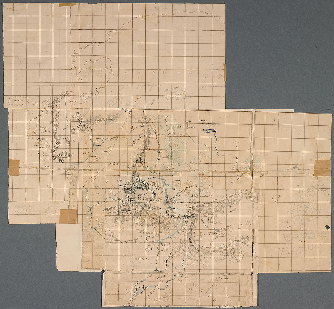
Almost the same scenario played itself out again for the 1955 release of The Return of the King. Tolkien wrote to his publisher (#161) about the map of Rohan, Gondor, and Mordor:
The map is hell! I have not been as careful as I should in keeping track of distances. I think a large scale map simply reveals all the chinks in the armour — besides being obliged to differ somewhat from the printed small scale version, which was semi-pictorial.
You can see the map he was referring to on the right, as reproduced in a Wired magazine article from five years ago, “See the Sketches J.R.R. Tolkien Used to Build Middle-Earth”:
This explains the “anomalous” nature of the contour lines that Crowe refers to in Christopher’s version of this map — he was, in fact, replicating the contour lines of his father’s map — his father felt that contour lines would be more appropriate to a large-scale map: where a “pictorial” or semi-pictorial map works well for a small-scale map (covering thousands of miles), it works less well for maps of smaller areas: imagine the map below with “real” pictures of mountains — amongst other problems, the individual mountains would impinge your view of geographic features to their north.
There’s much more to be said about Tolkien’s original maps, but — other than the “Wilderland” map for The Hobbit — Tolkien never was able to create versions for publication. Christopher did a remarkable job in discerning, interpreting, and reproducing his father’s maps for publication. But they really are faithful reproductions of his father’s maps; we should consider redirecting most of the credit that we’ve recently been giving to Christopher regarding his influence on the modern fantasy genre as a whole back to his father.